
About this Event

Kelantan extreme flood, December 2014: Causes, extend and illustrations
Dr. Edlic Sathiamurthy, Universiti Malaysia Terengganu
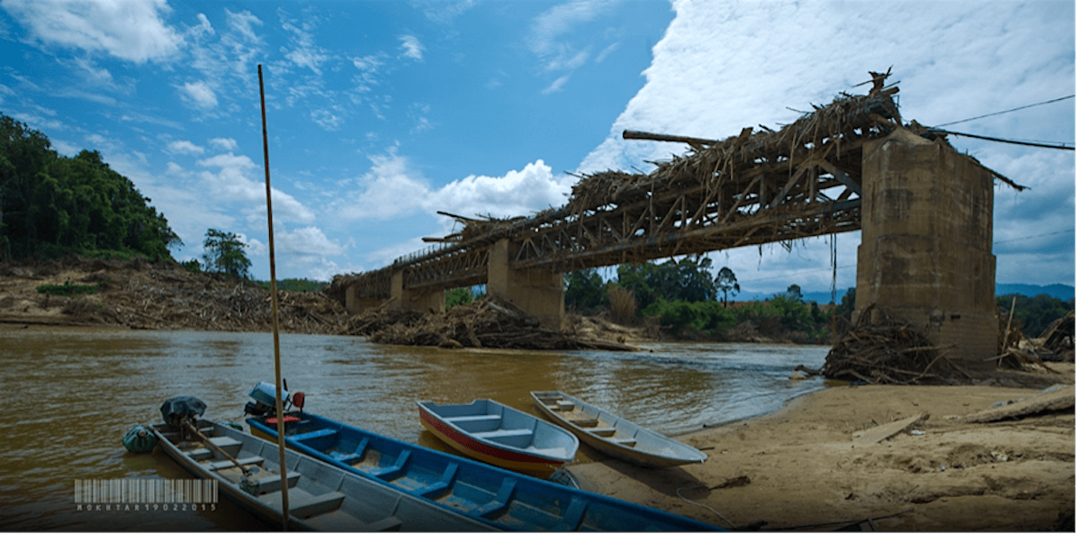
Kemubu Bridge (Peel Bridge), Kelantan: A section of the cast iron railway bridge (weighs about 50-60 metric tons) built during British Colonial era broke away under the power of flood flow. The section was found several hundred meters downstream. A testament to the power of the flood event. Source: Mokthar, UMT, 2015.
Abstract: Extreme floods occurred in several states of Peninsular Malaysia in December 2014. One of the hardest hit states was Kelantan. This presentation focuses on the central part of Kelantan River basin floods, 18-31 December 2014. Extreme rainfalls, geological setting and topography triggered the basin wide extreme event which only occurred twice in 88 years of flood records (1926-2014). The extent of the flood within the central and upper Kelantan River basin is shown on a flood map generated using water surface gradient interpolation extracted from water level data of existing telemetry stations located along the river system while the lower basin used radar satellite data. The flooded area was about 220 km2 (about 30% of Singapore in comparison) with flood depths ranging from 1.5 m to 9.5 m. The map was overlaid on a mosaic of fine scale Google Earth images for Dabong, Manik Urai and Kuala Krai (these were the worst areas) towns to visualize the human landscape affected by floods. It is concluded that physical factors, i.e. geological setting and topography are crucial in the analysis of the cause and effect of severe floods, and spatial distribution of flood depths when the terrain characteristics are considered. This presentation also provides photographic evidence gathered by University Malaysia Terengganu flood forensic team that conducted post-flood field observations on the 15 January 2015. Just like the old saying, “A picture is worth a thousand words”, these photographs capture the destruction of infra structures and shattered lives of victims. Furthermore, these photographs provide forensic evidence of the flood dynamics. This presentation is based on the combined work the forensic team and research assistants.
Bio: Dr. Edlic Sathiamurthy is currently an Associate Professor at the Faculty of Science and Marine Environment, Marine Geoscience Program, Universiti Malaysia Terengganu. He obtained his bachelor's degree in Geography from the University of Science Malaysia (1996), M.Tech. from University of Malaya (1999) and Ph.D from Nanyang Technological University (2006). His background is flood modelling for coastal zones. He also work on the palaeo fluvial system of Sundaland.
----------------------------------------------------------------------------------------------------
Topic: ASE & EOS Seminar Series
Time: Feb 24, 2026, Tuesday, 12:30 - 1:30 pm Singapore
Physical access: ASE Lab/Lecture 1 (N1.1-B2-01b)
Virtual access:
https://ntu-sg.zoom.us/j/81193040764?pwd=wQqMFWgzUb9r4XkcBnG3N9UU4zwfmi.1
Meeting ID: 811 9304 0764
Passcode: 943686
----------------------------------------------------------------------------------------------------
Event Venue & Nearby Stays
Asian School of the Environment (ASE), ASE Lab/Lecture 1 (N1.1-B2-01b), 59 Nanyang Drive, Jurong, Singapore
USD 0.00


